THE LOST COLONY OF ROANOKE
| PERIOD | Colony established July 1587; found deserted August 1590 |
| LOCATION | Roanoke Island, present-day Dare County, North Carolina |
| MISSING | 115 English colonists, including Virginia Dare, the first English child born in the Americas |
| STATUS | Open. Archaeological evidence increasingly favours dispersal and assimilation |
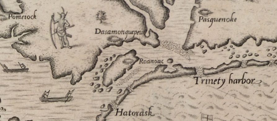
THE CLAIM
That an entire English colony disappeared without trace. This framing is itself the main thing this file exists to correct: the colonists left an explicit indication of where they were going, and the modern archaeological question is not whether they vanished but which of two or three destinations they split toward.
THE THEORY, AS ITS PROPONENTS TELL IT
The popular framing, that 115 colonists vanished without trace, is the thing this file exists to correct, and it is why the serious theories are archaeological rather than conspiratorial.
The colonists left instructions. Governor John White had agreed with them that if they relocated they would carve the destination, and that if they were in distress they would add a Maltese cross. He returned in 1590 to find the settlement dismantled rather than destroyed, no bodies, no sign of struggle, CROATOAN carved on a post and CRO on a tree, and no cross. Croatoan was both a place, present-day Hatteras Island, and the people living there, who were the only group friendly to the English. A storm prevented him from sailing the fifty miles to check, and he never returned.
The two leading destination theories are now being tested with trowels. The First Colony Foundation's excavations at Site X near Salmon Creek in Bertie County, at the head of Albemarle Sound, have recovered late-sixteenth-century English pottery consistent with the colonists; long-running work on Hatteras Island directed by Mark Horton has produced English material in Native contexts. The prevailing reading is that the group split, with some going to Croatoan and some inland.
The pressure that forced the move is documented independently: tree-ring reconstruction shows 1587–1589 as the most severe drought in the region in roughly 800 years. The remaining theories (Spanish attack, or massacre by the mainland Secotan, with whom the previous English expedition had left relations poisoned) are possible and unevidenced. Seventeenth-century English reports of grey-eyed people among the coastal tribes who claimed to read books are late, secondhand, and tantalising.
WHAT IS KNOWN
In July 1587, 115 colonists under governor John White landed on Roanoke Island under Sir Walter Raleigh's charter. White's granddaughter Virginia Dare was born there that August, the first English child born in the Americas. Relations with the local Secotan were already poisoned by the violence of the previous English expedition.
White sailed for England for supplies. He intended to return within months. Instead the Spanish Armada and the wider Anglo-Spanish war commandeered every available ship, and he did not set foot on Roanoke again until August 1590, three years later.
He found the settlement dismantled rather than destroyed: the houses taken down, a palisade erected, no bodies, and no sign of a struggle. Carved on a post was the word CROATOAN, and on a nearby tree the letters CRO. Before leaving, White had agreed a code with the colonists, if they moved, they would carve the destination, and if they were in distress they would add a Maltese cross. There was no cross. Croatoan was both a place, present-day Hatteras Island, and the people living there, who were the one group friendly to the English.
White never reached it. A storm damaged his ships, the crews refused, and he was carried back to England. He died without learning what became of his family.
Modern archaeology has moved the question forward considerably. The First Colony Foundation's excavations at "Site X" near Salmon Creek in Bertie County, on the mainland at the head of Albemarle Sound, have recovered late-sixteenth-century English pottery of a type consistent with the colonists. Separate long-running excavations on Hatteras Island directed by Mark Horton have produced English material in Native contexts. Independently, tree-ring reconstruction shows that 1587–1589 was the most severe drought in the region in roughly 800 years, a subsistence catastrophe for a new colony.
Seventeenth-century English accounts record reports of grey-eyed people among the coastal tribes who claimed to read books, though these are secondhand and were collected decades later.
EVIDENCE FOR
- The colonists left a written destination and deliberately omitted the agreed distress signal, evidence of a planned relocation, not an attack.
- The settlement was dismantled, not burned; the absence of bodies or battle debris across a substantial site argues strongly against massacre.
- English artefacts of the right period have now been recovered at two separate candidate destinations, one inland and one at Hatteras.
- Tree-ring data establish an extreme drought precisely during the abandonment window, supplying a compelling reason to move.
- Splitting a group of 115 between a friendly island community and a mainland site is exactly what a colony short of food and three years past its resupply date would do.
EVIDENCE AGAINST
- No burial, no European skeletal remains, and no unambiguous colonist artefact in a securely dated context has yet been recovered at either site.
- The recovered English material could have reached Native communities through trade or salvage without the colonists themselves ever arriving.
- The grey-eyed Indian reports are late, secondhand, and were collected by people with an interest in the story.
- Spanish attack was a live possibility at the time and has never been formally excluded, though Spanish records give no account of it.
ASSESSMENT
OPEN, but narrowing, and this office regards the popular framing as the real error in the file. Roanoke is presented perennially as an inexplicable vanishing, when the colonists left a signpost, omitted their distress code, and disappeared into precisely the drought and the diplomatic situation you would expect to force a move. The mystery is not what happened to them. It is which direction each group went, and whether their descendants are still on that coast. That is an archaeological question with a plausible answer, and two active digs are working on it.
WHAT WOULD CHANGE THE GRADE
- To CLOSED: an artifact assemblage with a clear English colonial signature at a site tied to the 1587 group. Excavations at Site X on Albemarle Sound and on Hatteras Island have produced suggestive material and nothing decisive.
- CROATOAN carved on the post was a pre-agreed signal naming a destination, and the agreed distress cross was absent. That single fact is the most informative thing in the file, and it indicates a planned relocation rather than a massacre.
- Assimilation into Croatoan and neighbouring communities is the leading explanation, and it is precisely the sort of claim that is difficult to demonstrate archaeologically. This file is open for lack of a method, not for lack of an answer.
FURTHER READING
- John White (U.S. National Park Service)nps.gov
- Roanoke Colony · Wikipedia
- First Colony Foundation, ongoing excavation reports on Site X and Site Y, Bertie County
- The Secret Token: Myth, Obsession, and the Search for the Lost Colony of Roanoke · Andrew Lawler, 2018
RELATED FILES IN THIS ARCHIVE
- OSA-187 · THE ANTIKYTHERA MECHANISMCONFIRMEDAn ancient Greek device whose complexity was not matched until the medieval period
- OSA-043 · THE VOYNICH MANUSCRIPTOPEN CASE240 pages in a script found nowhere else on Earth
- OSA-047 · THE OAK ISLAND MONEY PITUNVERIFIED230 years of digging, six deaths, zero treasure
- OSA-079 · THE HOLLOW EARTHDEBUNKEDOnce a Royal Society hypothesis, now closed by seismology